1906: The Day the Ocean Rose — Ecuador's Largest Earthquake Ever
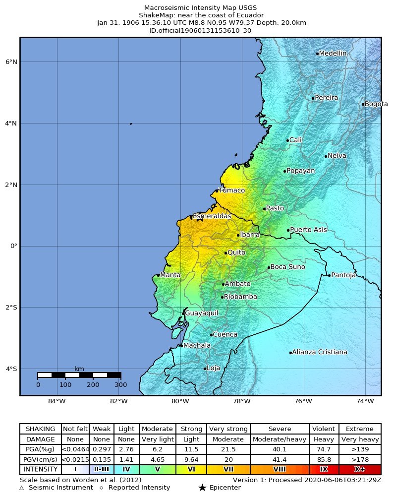 On the morning of January 31, 1906, the seafloor off Ecuador's northern coast tore open along roughly 400 kilometers of the subduction zone where the Nazca plate dives beneath South America. The earthquake that followed — estimated at magnitude 8.8 — remains the largest ever recorded in Ecuador and among the largest ever recorded anywhere on Earth.
The epicenter was offshore, roughly 32 kilometers from the coast near Esmeraldas. The shaking was severe along the northern coast, but it was the ocean that did most of the killing. The quake generated a tsunami that struck the coastline from Río Verde in Ecuador north to Micay in Colombia. At Tumaco, Colombia, waves reached an estimated five meters. The wave was recorded as far away as Panama, California, Hawaii, and Japan.
Estimates of the dead range from 500 to 1,500 people, the majority taken by the tsunami rather than the shaking itself. Coastal villages built at sea level, with no warning system and no living memory of such an event, had minutes at most.
**What happened inland**
The felt area was enormous. In the northern Sierra, towns including Ibarra, Cotacachi, and Otavalo suffered damage — church collapses feature prominently in the historical accounts. Quito felt moderate shaking. But the intensity fell off steadily with distance from the rupture.
And Cuenca? The historical record shows no documented damage here. Sitting far to the south, inland and at altitude in the southern Andes, Cuenca was at the edge of the felt area — residents would have noticed the shaking, but the city came through 1906, the largest earthquake in the country's history, essentially untouched.
**The unfinished story**
The 1906 rupture zone did not stay quiet. Sections of it broke again in 1942, 1958, and 1979, and most recently in the 2016 Pedernales earthquake. Seismologists estimate that those subsequent earthquakes have released only about a third of the strain the plate boundary has accumulated since 1906 — which is why the Ecuador–Colombia margin remains one of the most closely watched stretches of subduction zone in the world. We'll look at that ongoing story — the seismic gap — later in this series.
*This article is part of CuencaLife's earthquake series with Marco. Historical figures drawn from seismological and historical records; early 20th-century casualty counts are approximate.*
On the morning of January 31, 1906, the seafloor off Ecuador's northern coast tore open along roughly 400 kilometers of the subduction zone where the Nazca plate dives beneath South America. The earthquake that followed — estimated at magnitude 8.8 — remains the largest ever recorded in Ecuador and among the largest ever recorded anywhere on Earth.
The epicenter was offshore, roughly 32 kilometers from the coast near Esmeraldas. The shaking was severe along the northern coast, but it was the ocean that did most of the killing. The quake generated a tsunami that struck the coastline from Río Verde in Ecuador north to Micay in Colombia. At Tumaco, Colombia, waves reached an estimated five meters. The wave was recorded as far away as Panama, California, Hawaii, and Japan.
Estimates of the dead range from 500 to 1,500 people, the majority taken by the tsunami rather than the shaking itself. Coastal villages built at sea level, with no warning system and no living memory of such an event, had minutes at most.
**What happened inland**
The felt area was enormous. In the northern Sierra, towns including Ibarra, Cotacachi, and Otavalo suffered damage — church collapses feature prominently in the historical accounts. Quito felt moderate shaking. But the intensity fell off steadily with distance from the rupture.
And Cuenca? The historical record shows no documented damage here. Sitting far to the south, inland and at altitude in the southern Andes, Cuenca was at the edge of the felt area — residents would have noticed the shaking, but the city came through 1906, the largest earthquake in the country's history, essentially untouched.
**The unfinished story**
The 1906 rupture zone did not stay quiet. Sections of it broke again in 1942, 1958, and 1979, and most recently in the 2016 Pedernales earthquake. Seismologists estimate that those subsequent earthquakes have released only about a third of the strain the plate boundary has accumulated since 1906 — which is why the Ecuador–Colombia margin remains one of the most closely watched stretches of subduction zone in the world. We'll look at that ongoing story — the seismic gap — later in this series.
*This article is part of CuencaLife's earthquake series with Marco. Historical figures drawn from seismological and historical records; early 20th-century casualty counts are approximate.*
Header photo / Foto de portada: Image: U.S. Geological Survey ShakeMap of the 1906 earthquake, public domain, via Wikimedia Commons